
Digital Twin 3D Building Scanning
3D Scanning for Buildings (Virginia and North Carolina) // starting at ¢10 per square foot ($500 minimum)

Missing a measurement can be costly; with a digital twin, all of your measurements live at the click of a button.
We will upload a 3D Building Scan walkthrough (dollhouse) to our Matterport site and host it for three months. This dollhouse model can be hosted to most websites, for your use and incorporation. If additional hosting is desired, we can accommodate for an additional monthly fee.
This service derived from a need for as-built construction documentation, we offer inclusion of cloud files for use in various BIM technologies and programs (Revit) in our standard form. Please call with any questions about capabilities and standard offerings.
Matterport offers additional features that may require an individual or separate account. Please visit their website for more information.
Please fill out the adjacent form to schedule a 3D Building Scan. We will reach out within 48 hours to confirm the date and provide an invoice for square footage and any additional features. Invoices must be paid at time of receipt and prior to the scan. If building square footage varies from information provided, a final invoice may be provided prior to release of scans.
**Base cost includes travel time within 1 Hour from Norfolk, Virginia. Travel time beyond 1 hour may be billed with invoice. Our focus is 3D Building Scans in Virginia and North Carolina


-
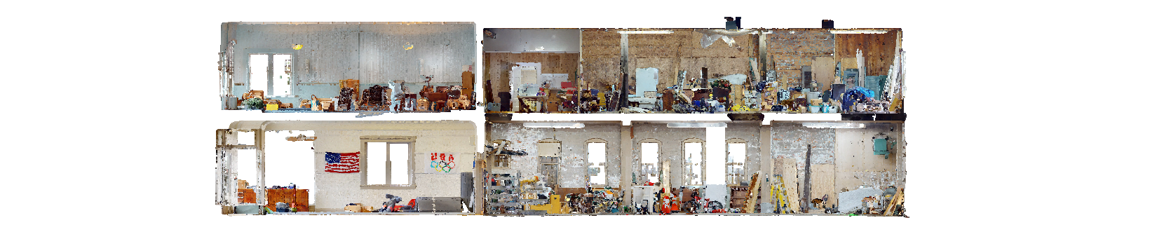
A point cloud is a discrete set of data points in space. Each point position has its unique set of Cartesian coordinates (X, Y, Z). We are utilizing point clouds to capture the existing (as-built) conditions of buildings and import them into BIM software workflows.
For additional information, please visit the matterport website here.
-
The majority of our efforts are in creating accurate as-built documentation for the AE industry. However, our chosen scanner does offer benefits for commercial and residential realtors. If your preference is only to provide a 360 walk through for tenants or clients to understand the space, a point cloud may not be necessary. No worries though, we can always activate the point cloud at a later date if the requirement emerges.
-
We would encourage you to view the following link for two separate workflows. We have personal experience with both and are happy to provide any troubleshooting assistance to make sure you get the most from your scan.
-
The stated accuracy of the machine is +/- 20mm @ 10m. This is a single scan in a controlled environment, models with multiple 3D scans outside controlled conditions will impact data accuracy.
In our experience, the accuracy is greater than (and faster than) traditional tape and laser. Not to mention the entire building is documented with photos and LiDAR information (assuming every space is accessible), dramatically reducing the requirement to revisit the building for additional information.
For peace of mind, we still take an old school laser tape and verify a couple of dimensions.